

NASA does a lot of things for Earth Day — data releases, awareness campaigns, and educational content. This year, they added something that’s just genuinely fun to play with.
It’s called “Your Name in Landsat,” and it launched specifically for Earth Day 2026. The idea is simple: type your name into the tool and watch it get assembled letter by letter using real satellite images of Earth’s surface. A river bend here, a desert pattern there, a coastline somewhere else — each character in your name gets matched to a natural landscape that happens to look like that letter when seen from space.
It takes about 30 seconds and produces something most people want to share immediately.
What Is ‘Your Name in Landsat’?
At its core, it’s an online tool that converts any name or word into a visual collage composed entirely of satellite imagery. Every letter is formed using actual natural features — rivers, dunes, forests, coastal outlines, agricultural patterns — that resemble alphabets when photographed from orbit.
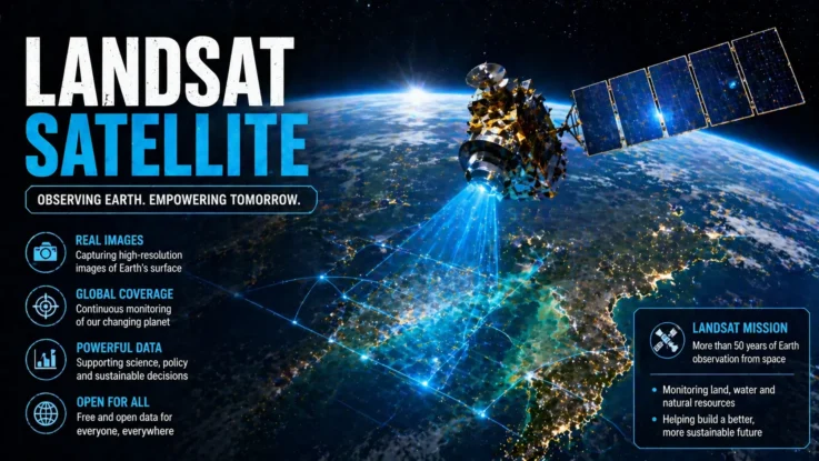
The images come from NASA’s Landsat programme, which has been continuously photographing Earth’s surface since the early 1970s. That’s decades of imagery covering virtually every corner of the planet, and that archive is what makes the tool work. Each letter you see is a real photograph of a real place, not a graphic design exercise.
How the Tool Works
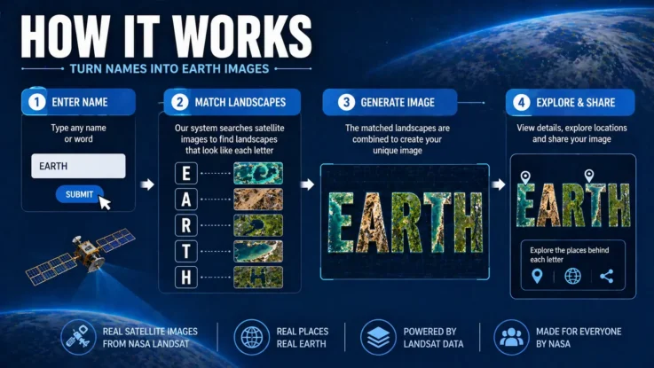
The process is straightforward. You visit the official Landsat page, type a name or word into the input field, and submit it. The system searches the satellite image database, finds landscape shapes that correspond to each letter, and assembles them into a visual output almost instantly.
What’s happening behind the scenes is more interesting — the tool is essentially doing pattern recognition across an enormous archive of geographic imagery, identifying natural formations that match letter shapes. It’s a genuinely clever application of data that was originally collected for scientific purposes.
Step-by-Step Guide to Create Your Name
- Visit NASA’s “Your Name in Landsat” website
- Enter your name or any word you want to visualise
- Hit enter to generate the image
- View your name assembled from satellite imagery
- Download or share the image directly from the page
There’s also a feature worth exploring once you’ve generated your name — clicking on individual letters reveals exactly where on Earth that image was captured, including the location name and precise coordinates. Your name might end up pulling images from five different continents.
Why NASA Launched This Initiative
The stated goal is to make Earth science more personal and accessible. Satellite imagery and geographical data can feel abstract and distant — important, certainly, but not something that connects emotionally with most people.
Turning someone’s own name into a series of real landscape photographs changes that dynamic. It creates a direct, personal connection to both the technology and the planet it documents. You’re not just reading about Landsat data — you’re looking at a specific river bend in a specific country that happens to form the first letter of your name.
The broader hope is that the curiosity this sparks leads people toward genuine interest in geography, environmental science, and what satellite observation actually contributes to our understanding of the planet.
The Role of the Landsat Program
Landsat is worth understanding beyond its role in this tool because the programme itself is remarkable. Running continuously since 1972, it has built the longest continuous record of Earth’s surface from space that exists anywhere.
Scientists use Landsat data to track glacial retreat, monitor deforestation, assess drought conditions, plan agricultural land use, respond to natural disasters, and understand long-term climate patterns. The same dataset that shows you a river shaped like your initial letter has also helped researchers document the shrinking of the Aral Sea, the expansion of the Sahara, and the growth of cities over decades.
The name generator is a fun entry point into a programme with serious scientific significance.
What Makes Each Name Unique
Because the tool draws from a genuinely vast archive of real imagery, no two outputs are identical — even for the same name. The selection process means your result today might pull different landscape images than the same name generated tomorrow.
That unpredictability is part of what makes it interesting. Your name might include a letter formed by a glacier in Iceland, another from rice paddies in Southeast Asia, and another from salt flats in South America. The combination is different every time, and each one reflects something real about the planet’s extraordinary geographic variety.
Also Read: How to Choose Among the Best EV Scooters in India for Daily Travel
Key Features of the NASA Tool
| Feature | Details |
|---|---|
| Tool Name | Your Name in Landsat |
| Launch Occasion | Earth Day 2026 |
| Function | Converts names into satellite image letters |
| Data Source | Landsat satellite imagery archive |
| Output Options | View, download, and share |
| Extra Feature | Shows exact location and coordinates per letter |
Worth Five Minutes of Your Time
What NASA has done here is find a way to make decades of scientific data feel personal and immediate to people who would never otherwise engage with it. That’s genuinely difficult to do well, and this tool does it well.
If you haven’t tried it yet, it’s worth five minutes. Type your name, see what corners of the Earth end up spelling it out, and maybe follow your curiosity a little further into what the Landsat programme actually does and why it matters.